Friday, August 30—Cottonwood Pass and Taylor Park Reservoir

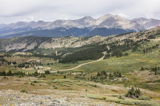
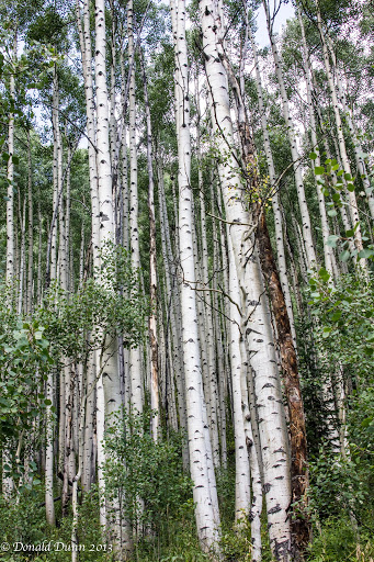
We cleared our schedule today in order to drive to Taylor Park Reservoir. We drove north to Buena Vista, turning west on Chaffee County Road 306. This paved road took us to the summit of Cottonwood Pass, at elevation 12,126 feet, also the Continental Divide, marked at the “saddle point” of  the pass. The area surrounding the pass is mostly forest, with the San Isabel National Forest to the east and the Gunnison National Forest to the west. Near the summit, the road name changes to Gunnison County Road 209 as it continues to the west, becoming gravel as it descends to near Taylor Park Reservoir. The pass is closed seasonally due to heavy snowfall, typically from around October until sometime in May. When open, the pass is one of the few routes through the Sawatch Range accessible in a standard two-wheel drive passenger vehicle. Independence Pass, which we traversed yesterday, is another such seasonal route through this mountain range, while efforts are made to ensure that U.S. 50 at Monarch Pass, which we crossed Tuesday and Wednesday, remains open year-round for all vehicles, barring extreme weather conditions.

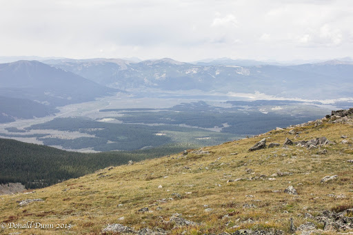
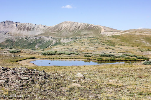
Wayne had told us about a campground, River’s End at Taylor Park Reservoir, and it exceeded his description; the reservoir is shown near the center of the photograph.  He had stayed at one of the great sites along the river, and the upper campsites overlooking both the river and the reservoir were incredible, especially when the cost is $0; wow! It would be a great place to spend the hot months of summer. One negative, however, is that we could not get a Verizon cell signal. While driving around the area, we noticed a lot of ATVs creating lots of dust. Of course, this is Friday of Labor Day weekend. On our return, a drizzle began. The Cottonwood Pass road was bumper to bumper from east to west with cars and trucks pulling trailers loaded to the hilt with ATVs, RVs pulling trailers filled with ATVs, etc. Apparently, a nationally prominent ATV event was happening in the area. With the crowded conditions, we made a quick exit.

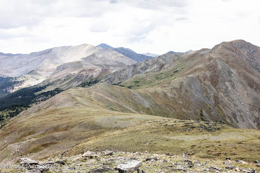
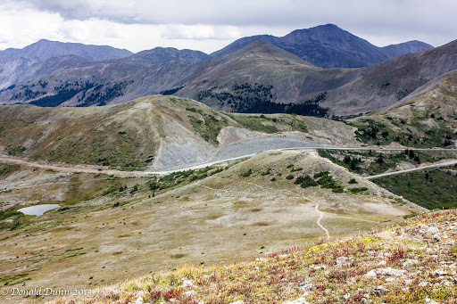
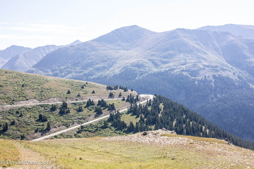
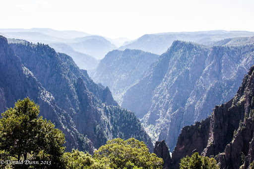
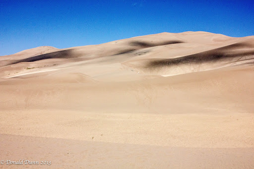
We stopped atop Cottonwood Pass on the return, and I hiked to the summit—Kay partway—of a nearby mountain, reaching almost 13,000 feet with occasional spitting rain mixed with the drizzle. The trail was marked by one switchback after another, and I had to stop often to catch my breath.  The next to last photo was taken atop the mountain, at almost 13,000 feet.  The last photo shows the switchback trail, and Kay near the bottom, is nearly invisible. The descent was much easier and faster.

We drove the rest of the way to Salida, expecting a quiet, peaceful evening. About 8 PM a family checked in across the hall with two pre-teen daughters and a small dog. The girls were in and out of the room every couple of minutes (no kidding), and talked loudly in the hall for the next couple of hours. A request, a rap on the door, and even a call to the front desk did not seem to deter them. We finally fell asleep amidst the noise only to be awakened by the dog about 12 o’clock midnight. Oh, what a night.

– Posted using BlogPress from my iPad

Thursday, August 29—The Maroon Bells

A decent weather forecast for today provided an opportunity to view the Maroon Bells and hike to Crater Lake, an awesome alpine lake where we can have lunch on the shoreline with the Bells in the background.

Our trip to Aspen took us over still another pass, Independence Pass. Independence Pass, at elevation 12,095 feet is on the Continental Divide in the Sawatch Range. The pass is midway between Aspen and Twin Lakes just west of Buena Vista. After Cottonwood Pass to the south, it is the second-highest pass with an improved road in the state, the fourth-highest paved road in the state, and the highest paved crossing of the Continental Divide in the U.S.

A scenic overlook near the pass allows visitors to take in the alpine tundra environment above treeline, and offers excellent views to the east of Mount Elbert, Colorado’s highest peak and the second-highest mountain in the lower 48 states. On the west side, the paved road is one way in several places, with rock overhangs above roadway. We made it up, over, and down without incident.

Vehicular, bicycle, and pedestrian traffic increased as we approached Aspen. Access to the Maroon Bells is now by $6 shuttle bus ride, except early and late in the day, because of the volume of “visitors” to the area. When I last visited, in the late 1970s, it was much less crowded. Anyway, the shuttle bus ran every thirty minutes, and we were unsure of the bus stop location; however, there was good signage, and we arrived, parked, bought tickets, and waited in queue just a short time. The bus filled to capacity with people and dogs–dogs on trails seem to be quite popular this year.

A narrated, sometimes funny bus ride ascended the valley, and dropped us off at Maroon Lake; there were people everywhere. We sought information from a National Forest Service volunteer who politely advised us to forego the hike to Crater Lake because of low water levels in the lane and poor trail conditions. She suggested we hike to the end of Maroon Lake, and then hike the loop trail to a small waterfall. It was an innocuous hike, but did provide some good views of the Maroon Bells.

We hiked along the lake edge looking for a place for lunch, and finally settled on a bench overlooking Maroon Lake and the Maroon Bells.

Rather than take the shuttle back down to Aspen, we opted to hike the 3.5 mile creekside trail, Maroon Creek Trail, partially down the valley, and catch the shuttle there for the remainder of the descent. Though downhill, the multi-use trail was more challenging than expected with misting rain and lots of horse manure to walk over, through, and around, making slick conditions even worse. We passed through and by several stands of aspen trees, gently “quaking” at the occasional puff of wind.

At the bus stop, we visited with other trail hikers waiting on the bus, including a family from Dallas, one from Waco, and a couple of young female models from New York. The quick bus ride ended near the parking lot, and we immediately began our drive back to Salida. Our intent had been to drive to Crested Butte, then over a couple of passes to Taylor Park Reservoir, and then back to Salida, but lack of time prohibited this route. Instead, we drove back over Independence Pass, and this time, Kay’s acrophobia got the best of her on a couple of occasions; but she just sat back, closed her eyes, and “enjoyed” the ride as best she could.

Finally down the mountain, we drove to Salida, and then to adjacent campgrounds—one private and one public—along the river that Wayne had suggested we investigate. Though there were some discernible differences, the major difference was price—the private campground was $30+ a night, the public campground was free!

Back in Salida, we saw the twin mule deer fawns again, munching grass next door to the motel.

An early, quiet evening ended the day.

– Posted using BlogPress from my iPad

Wednesday, August 28—Black Canyon of the Gunnison NP


Different town, different hotel, and different bed equals no sleep. Consequently, it was another early morning, enabling us to leave the hotel early.

We drove west, over Monarch Pass at elevation 11, 312 feet.  Monarch Pass is located on the Continental Divide at the southern end of the Sawatch Range, approximately 25 miles west of Salida, our home away from home for the next 4 nights.  The pass can be used by all vehicles under most conditions, with some 7% grades, and is generally open year-round.  It is widely considered one of the most scenic in Colorado, offering a panoramic view of the southern end of the Sawatch Range from the summit.

After descending Monarch Pass, we drove through the town of Gunnison, and continued west past  Blue Mesa Reservoir, a beautiful man-made reservoir. It reminded us of Lake Powell in Arizona, with sheer rock walls and beautiful blue water.  From there, we traveled further west to Black Canyon of the Gunnison National Park.  I last visited Black Canyon of the Gunnison NP in the late 1970s, and it was a very quick “take a picture and drive” type of visit. This trip was different—Kay and I hiked every trail to every overlook, totaling well over 3 miles, and at an elevation of 8,500 feet!  Regrettably, photographs, at least those I take, do not do it justice.

The area was established as a U.S. National Monument on March 2, 1933, and made into a National Park on October 21, 1999. The trails and overlooks, and all other infrastructure for that matter, were among the best of any national park or monument we’ve visited.

The Black Canyon is over 2,700 feet at its greatest depth; its narrowest width is 1,100 feet at the rim and only 40 feet at the river. While the canyon is 53 miles long, only 14 miles are within the national Park; the remainder lies under two impoundments, including Blue Mesa Reservoir mentioned above. Average descent over the entire length of canyon is 43 feet/mile, and the greatest decent is 240 feet/mile.

As we were leaving the park, we saw a mule deer doe eating along side the road, getting ready for fall and winter.

We were pooped and hungry after all the hiking, and drove to Montrose for a late lunch/early dinner. Montrose is a much larger city than what we expected, comparing with Jonesboro, Fayetteville, etc.

A long drive back to Salida, over Monarch Pass, got us to the hotel just before dark, where we were greeted by a couple of mule deer fawns munching nearby.

Tuesday, August 27—Great Sand Dunes and South Central Colorado

Changing time zones again—from Central to Eastern to Central to Mountain—we were up earlier than everyone else. Breakfast consisted of items from the food bar at the hotel in Pueblo, Colorado.


We drove south to Walsenburg, then west to Great Sand Dunes National Park. Yellow wildflowers covered each side of the road long the way, and made for a spectacular drive. The dunes looked so small from afar when compared to the mountains behind them. However, they loomed larger and larger as we drove closer. The Visitors Center was small, and provided the usual National Park Service information including a map and seasonal newspaper.


Leaving the car at the Dunes parking lot, we walked through powdery sand to the base of the dunes, took some photographs, and returned to the car rather than try to climb any of the dunes.

We continued driving west to South Fork, and began to notice evidence of the fires from earlier this summer. From South Fork we drove towards Creede, passing by the entrance of the 4UR Ranch, thinking of our good friends, Ed and Linda, who typically go there every summer.

Past Creede we saw a stopped vehicle along the road and immediately saw a moose cow and calf munching on low hanging leaves along the road.  Their eating was unaffected by us observers on the roadside.

From there we drove over two passes that exceeded 10,000 feet in elevation, before reaching Lake City. Driving north to Gunnison, and then east over Monarch Pass at 11,312 feet, we arrived in Salida about 6:30 PM. Finding a decent restaurant proved difficult, so we checked into the hotel, and drove a short distance to a local Mexican eatery recommended by the hotel owner.

The rest of the evening was spent recovering from the long day.

Monday, August 26—Finally, Colorado

This year we had an opportunity to include a fly and drive trip to Colorado, allowing us to do another life list item.  We left home about 8:30 AM, driving to North Little Rock, where friend Betty took us to the airport.


Our non-stop United Airlines flight departed on time and arrived in Denver about a half hour early. After picking up the checked baggage, we caught a shuttle to the Advantage Rental Car; after confirming the rental a few weeks ago, we read the most horrific reviews regarding Advantage we had ever seen. Consequently, we were very cautious when actually signing the agreement. And, true to the negative reviews, we found long lines and waiting times, the partially-English-speaking employees trying her best to upgrade us beyond what we had asked for, and would not take no for an answer. Nevertheless, we made it through the process relatively quickly, with no additions to our bill, checked car, and loaded our luggage.

There was extremely poor signage exiting the airport, and we wanted to avoid toll roads, as unbeknownst to us the rental agreement included a tremendous charge for electronic tolls. (We’re still not sure that we avoided toll roads, but will find out when we settle up our final bill.) As luck would have it, we began driving south about the same time rush-hour struck the Denver metro area. The combination of rush-hour and construction caused traffic to back up for about an hour between Denver and Colorado Springs. The drive from Colorado Springs to Pueblo was much less stressful, with very little traffic, Though construction activities played havoc with our drive.

We ate dinner at Cracker Barrel, a very reliable restaurant, during which friend Joey called regarding our recent Wisconsin and Michigan trip. Sometimes I underestimate the power of the written word, and have had several comments from people who read the blog who say that they can very easily tell when we like an area, or even dislike an area.  Such was the case for Wisconsin—while we did not particularly care for Copper Harbor, the UP, or Mackinaw City, we really liked Door County, Wisconsin, and Petoskey, Charlevoix, and the Traverse City areas of Michigan; we hope that doesn’t overly influence others who might want to visit those places.

After dinner, we checked into the hotel and called it a night.

Wednesday thru Sunday, August 21-25–TCBY

Home for only 5 days means taking care of business–the motorhome, the house, financial matters, and church–before we leave again.

Wednesday was spent washing and drying the motorhome after its recent 2,600-mile trip, completing unloading, preparing it for some idle time, and attempting a repair on the hood hinge. With higher temperatures than what’ve had experienced in several weeks, an early start during the coolness of morning was necessary. The wash job went quickly, particularly with both of us working. Kay took care of unloading her clothes and the remaining groceries in the pantry and refrigerator/freezer, and preparing the refrigerator/freezer for down time until we use it again. Tire covers were put on to prevent sun damage, but the hood hinge repair failed; Gorilla glue just wouldn’t hold. By the time all these were finished, we were hot and tired. We took advantage of the afternoon for some “personal care” activities and then back home in the chilled air, I worked on photos.

Thursday morning I drove into town to purchase 5-minute epoxy gel for use in another hood hinge repair; this is the adhesive recommended by Lichtsinn RV, the dealership in Forest City, Iowa, where we bought the motorhome. Kay and I spent a couple of hours on Norfork Lake, just floating and drifting alongside the pontoon. After returning home, we mixed the epoxy, applied it to the appropriate surfaces, and clamped the two braces–we’ll see. We used the evening catching up on missed, but saved television programs.

John Simank invited me for fishing the White River on Friday, which I eagerly accepted as I wanted to learn to fish high water. John is the best boat fisher with a fly rod I know, and today proved it again. With varying water discharges and levels, he caught fish when no one else was even getting a bite. I did not fare as well, catching only half a dozen fish. It was hot, and he had prepared a gourmet lunch (mainly for his out of town guests who were fishing with a guide). Friday evening, kay and I joined his guests and he and Sandy for a sumptuous dinner featuring shrimp and scallops smothered in a heavy cream sauce–um good!

We began packing in earnest Saturday morning for our upcoming 12-day trip to Colorado. With checked baggage costing an arm and a leg (actually $25 a bag) and limited to 50 pounds, we are packing conservatively, planning to wash clothes at least a couple times while traveling. But, with a lot of outdoor activities planned, it’s difficult. We took advantage of the warm weather and enjoyed a few hours back on Norfork Lake. The evening just disappeared…

Finally, we were back in church and Sunday school, if only for one Sunday before we leave again. It sure was good hearing Randy preach, and listening to the lively Sunday school lesson about John Wesley, facilitated by Dr. Paul Wilbur. Afterwards, we joined Al and Gaye for an early lunch at Chen’s, one of our favorites. Finishing packing became our priority for the rest of the day.

– Posted using BlogPress from my iPad

Friday, August 23—Boat Fishing with John

DATE:  Friday, August 23, 2013

TIME:  9:00 AM TO 4:00 pM

WEATHER: Low 90s, sunny

WATER CONDITIONS:  Variable units

LOCATIONS FISHED:  White River, immediately below Bull Shoals Dam

FLIES USED: #14 Superfly, #20 red/silver midge pupa

ROD USED:  9 ‘ 6-wt Winston BII

HATCHES: Midges, occasional caddis

OTHER: John Simank invited me for fishing the White River on Friday, which I eagerly accepted as I wanted to learn to fish high water. John is the best boat fisher with a fly rod I know, and today proved it again. With varying water discharges and levels, he caught fish when no one else was even getting a bite. I did not fare as well, catching only half a dozen fish. It was hot, and he had prepared a gourmet lunch (mainly for his out of town guests who were fishing with a guide). 

Tuesday, August 20—Home

130731 WIMI E K 001


We left Rend Lake about 8:00 AM, driving south on I-57, crossing over the Mississippi River at Cairo, Illinois. At Sikeston, Missouri, we left I-57 switching to US Highway 160/US Highway 67, and then just US Highway 67 into Arkansas to US Highway 62. At Imboden, we were in familiar territory, headed west. We arrived home just after 2:00 PM, and fund everything lush after the 13+ inches of rain that fell in the last 5 weeks.

We spent the rest of the day unpacking and getting settled back in to the house.

As previous blog entires stated, we really enjoyed some parts of Wisconsin and Michigan, and found others to blasé. Surprisingly, the ones we enjoyed most were ones with our lowest expectations, and conversely, the ones for which we had the highest expectations proved to be our least favorite. Door County, Wisconsin, was definitely our favorite.


Monday, August 19—Rend Lake, Illinois

130819 WIMI E 001

With over 400 miles to go before stopping for the evening, we dreaded the rough roads out of Michigan, unknown commuter traffic into Gary, Indiana, and Chicago, Illinois, from the west, and questions about our route connecting to I-57 in Illinois; however, we were more than ready to leave South Haven and head south towards home. The roads in Michigan once again proved to be the worst of our trip, but traffic was not too bad. Turning south, we drove through northern Indiana, west of South Bend, and found the roads to be acceptable, and traffic light. Finally crossing into Central Daylight Savings Time and Illinois, we found I-57 to be a pleasant drive despite occasional work. Kay read somewhere that Illinois had more traffic than any other state. We only stopped three times in the 8-hour trip, and made good time to Gun Creek Campground on Rend Lake, southeast of St. Louis.

Gun Creek Campground on Rend Lake was just west of I-57, and a pleasant surprise. 130819 WIMI E 006 e had stayed at Rend Lake before and found it to be a typically great US Army Corps of Engineers facility. When planning a stop at Gun Creek, we were under the impression that all they had was 50A electricity, but found they have full hookups, including sewer, and after finding our I was retired from the US Army Corps of Engineers, the park attendant assigned us a site overlooking the lake; we couldn’t have chosen better! Set up was quick as we only plugged in, and leveled, since we would be using stored water in the RV.

Sunday, August 18—South Haven, Michigan

Leaving Indigo Bluffs was a mixed bag as we really enjoyed the luxury RV resort and met two very nice couples with whom we very much enjoyed visiting. We also liked Traverse City and all the surrounding villages and towns. There were opportunities to do lots of things. But, we also needed to drive south.

130818 WIMI E K 004

Our experiences with Michigan roads has been less than positive. It seems like some of the highways are good, and then in the cities and small villages, the roads turn to pot…holes. It is especially bad in our RV, as we can feel every bump in the washboarded roads compared to a very smooth ride on non-concrete roads. Consequently, we took a longer, but smoother route.  

We arrived at Sunny Brook RV Resort shortly after lunch, checked in, and set up. It is rated as a 10/10/10—a perfect score— by Trailer Life, but we would rate it more somewhat lower based on the facts that RVs are lined up in rows, with very little vegetative screen between them, and we had a couple of dogs close by that barked constantly. The internet was sporadic, but the pool and hot tub were great. We’d stay there again, but only when passing through. As for South Haven, the downtown area and Lake Michigan shoreline were nice, and lots of folks were making their way to the beach for the sunset. Otherwise, there doesn’t seem to be too much to do.